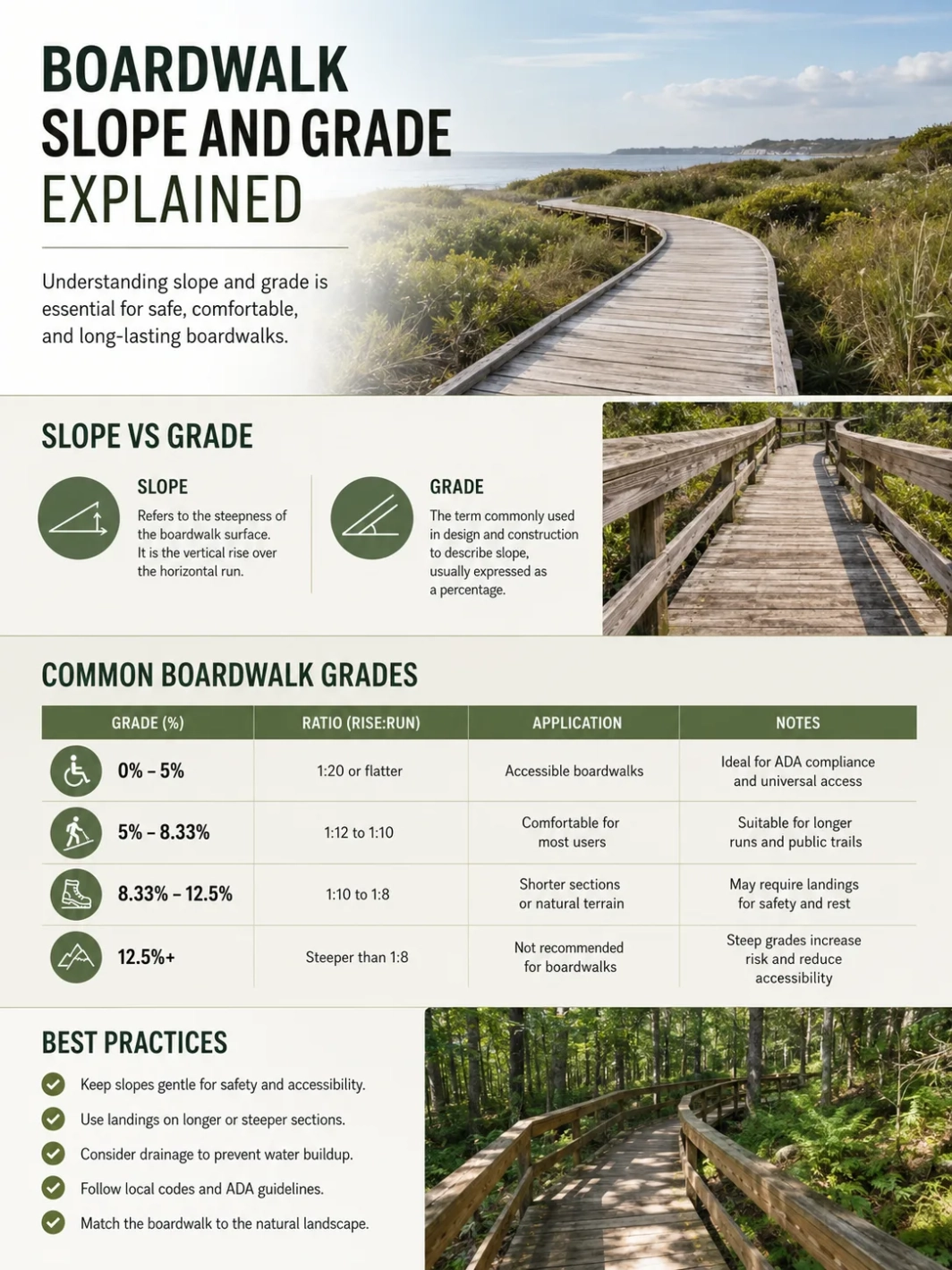
Boardwalk slope is the steepness of the walking surface. Grade is the same idea written as a percentage, such as 5%. On a boardwalk, the most useful distinction is between running slope, which follows the direction of travel, and cross slope, which tilts side to side for drainage.
| Term | Plain Meaning | Common Boardwalk Use | Practical Visitor Impact |
|---|---|---|---|
| Running Slope | The uphill or downhill slope along the walking direction. | Used to describe ramps, approach paths, elevated trail sections, and long boardwalk runs. | Affects wheelchair effort, stroller handling, walking fatigue, and rest needs. |
| Cross Slope | The side-to-side tilt across the boardwalk width. | Used to drain water off planks, decking, or paved approach routes. | Too much side tilt can pull mobility devices sideways and make walking less steady. |
| Grade | Slope written as a percentage. | A 1:20 slope equals a 5% grade; a 1:12 slope equals about 8.33%. | Grade numbers help visitors compare routes before arriving. |
| Resting Interval | A relatively level space along a steeper route. | Used where steeper outdoor recreation access route segments require a pause point. | Gives visitors a place to stop, turn, or recover before continuing. |
1:20 equals a 5% grade.
Running slope follows the route.
Cross slope controls drainage.
Site rules vary by setting and land manager.
What Slope and Grade Mean on a Boardwalk
Slope is usually written as a ratio of rise to run. A 1:20 slope means the walking surface rises 1 unit vertically for every 20 units of horizontal distance. When the same measurement is written as a percentage, it becomes grade. The Forest Service accessibility guidebook explains this conversion directly: 1:20 is a 5% grade [b].
For visitors, grade is easier to understand than a ratio. A 2% grade feels nearly flat to many walkers. A 5% grade is still gentle for many outdoor routes but begins to matter for wheelchairs, walkers, and strollers. An 8.33% grade, also written as 1:12, can feel much more like a ramp and may require shorter segments, landings, or resting intervals depending on the route type.
Technical note: A boardwalk can fall under different rules depending on whether it is a trail, beach access route, outdoor recreation access route, park walkway, urban promenade, or part of an accessible route. Local codes, federal standards, site terrain, and the managing agency can all affect the final design requirement.
Running Slope vs Cross Slope
Running slope is measured along the length of the boardwalk. It tells a visitor whether the route climbs, descends, or stays nearly level. On elevated wetland boardwalks, designers often try to keep running slope low because the route may be used by families, older visitors, mobility-device users, birders carrying gear, and school groups moving slowly.
Cross slope is measured across the width of the boardwalk. A small cross slope helps water move off the deck instead of sitting on boards, fasteners, anti-slip strips, or joints. Too much cross slope can make a boardwalk tiring because the user is constantly resisting a sideways pull.
The U.S. Access Board’s outdoor developed areas guidance treats slope, cross slope, resting intervals, surface, passing spaces, tread obstacles, and openings as separate technical topics for trails [a]. That separation matters because a boardwalk can be easy in one way and difficult in another: a flat route with a strong side tilt may still be uncomfortable, while a short uphill section with a level resting area may be more manageable.
| Design Feature | Direction Measured | Why It Exists | When It Becomes a Problem |
|---|---|---|---|
| Running Slope | Lengthwise, in the direction of travel. | Allows the boardwalk to climb dunes, clear roots, reach overlooks, or meet elevated platforms. | Long climbs without rest areas can be tiring and may limit wheelchair access. |
| Cross Slope | Side to side, across the walking surface. | Helps water drain from the surface. | Excessive side tilt can make mobility devices drift and can feel unstable on wet decking. |
| Transition Slope | Where boardwalk meets pavement, gravel, sand mat, or trail tread. | Connects different surfaces and elevations. | A lip, dip, or abrupt ramp can be more difficult than the boardwalk itself. |
| Landing Slope | On resting areas, turns, overlooks, and viewing nodes. | Provides a pause point or turning space. | If the landing is not level enough, it may not function well as a true rest area. |
Common Grade Numbers and What They Feel Like
Grade numbers are not just engineering labels. They change how a route feels underfoot. A nearly level boardwalk can feel relaxed, predictable, and easy to pause on. A moderate grade can still be usable, but the route may need shorter steep segments, better landings, handrails where required, and clear visitor information.
| Slope Ratio | Grade | Plain Reading | Boardwalk Relevance |
|---|---|---|---|
| 1:50 | 2% | Very gentle. | Often close to the kind of slope used for drainage or near-level walking surfaces. |
| 1:33 | About 3% | Still gentle, but side slope can be felt by some users. | Relevant to outdoor recreation access route discussions for cross slope and resting areas on some surface types. |
| 1:20 | 5% | A mild uphill or downhill grade. | A common threshold in accessibility guidance for walking surfaces and outdoor routes. |
| 1:12 | 8.33% | A ramp-like slope. | Can be used only with care in many access contexts and may require rest or landing design. |
| 1:10 | 10% | Noticeably steep for many visitors. | In Forest Service outdoor recreation access route guidance, this appears as an upper limit for short steeper segments, not a preferred target. |
Field note: A boardwalk can feel steeper in rain, frost, strong wind, or crowded conditions. Surface texture, handrail placement, plank direction, and the quality of the transition from parking area to boardwalk can change the visitor experience as much as the grade number.
Accessibility Rules, Outdoor Routes, and Resting Intervals
Outdoor boardwalks are often built in places where a perfectly flat route is not realistic: dunes shift, wetlands flood, roots grow, and viewing platforms may need to sit above sensitive ground. Accessibility guidance responds to that reality by separating route type, slope, surface, width, resting intervals, and exceptions.
For outdoor recreation access routes, Forest Service guidance says route sections of any length may have a running slope up to 1:20, or 5%. Shorter segments may be steeper, but the same guidance says an outdoor recreation access route may never exceed 1:10, or a 10% grade. It also explains that cross slope limits differ by surface, with board-built or paved surfaces held to tighter cross-slope control than natural or gravel surfaces [c].
Accessibility note: The word “accessible” should not be guessed from appearance. A boardwalk may look smooth but have a steep approach, a difficult transition lip, narrow passing areas, wet-season closures, or side slopes that affect mobility-device users. Use the managing agency’s current trail page when access details matter.
Why Resting Intervals Matter
A resting interval is a level or nearly level place where a visitor can pause. On a boardwalk, it may appear as a landing, a wider deck, a viewpoint, a bench area, or a turnout beside the travel path. The design goal is simple: do not make every visitor climb continuously without a usable pause point.
Resting intervals also support two-way traffic. They give people using mobility devices, families with strollers, photographers, and slower walking groups more room to manage pace without blocking the route.
Where This Shows Up on Real Boardwalks
Real sites show why grade details should be published clearly. Some land managers provide exact grade, cross-slope, width, surface, and trail length information. Others give a simpler access description, such as “flat surface” or “accessible boardwalk.” Both are useful, but exact grade data gives visitors a better pre-visit decision.
| Example Site | Location | Relevant Slope or Grade Detail | Why It Matters | Visitor Access Note |
|---|---|---|---|---|
| Happy Creek Forest Walk | North Cascades National Park, Washington | NPS lists a 0.3-mile boardwalk, 0–8.3% inclination, 0–3% overall cross-slope, 6-foot trail width, and boardwalk surface. | Shows how a short accessible boardwalk can still include measurable grade variation. | NPS warns that the boardwalk can be slippery when frosty or wet [d]. |
| Gambrill Mill Trail | Monocacy National Battlefield, Maryland | NPS lists a 0.5-mile loop with boardwalk for the first 0.18 miles, 6-foot trail width, 1% typical grade, 4% maximum grade, 4% typical cross slope, and 8% maximum cross slope. | Gives visitors exact grade and cross-slope numbers instead of a vague “easy trail” label. | Low-lying portions may flood, so surface condition can change after wet weather [e]. |
| Egret Trail | Horicon National Wildlife Refuge, Wisconsin | FWS describes a 1-mile route with asphalt, boardwalk, and crushed gravel, with smooth level surfaces and no slope more than 5% grade. | Connects boardwalk grade information to marsh access and mixed-surface trail design. | The trail is accessed from the midway parking lot of the refuge auto tour off Hwy 49 [f]. |
| Boardwalk Loop | Congaree National Park, South Carolina | NPS describes the 2.6-mile boardwalk as a flat accessible surface. | Shows how low grade helps a longer elevated route work as an introductory park experience. | Current access can be affected by boardwalk work, storms, flooding, or park detours, so the NPS page should be checked before visiting [g]. |
Design Pressures That Affect Boardwalk Grade
A boardwalk grade is rarely chosen in isolation. Designers often have to balance visitor access, drainage, flood clearance, habitat protection, maintenance access, structure height, and the elevation of nearby paths or parking areas.
Wetland Clearance
Why it matters: A boardwalk may need to sit above wet soil, seasonal water, or sensitive vegetation. The route then needs gentle approaches instead of abrupt climbs.
Dune and Beach Access
Access pressure: A dune walkover may need to rise quickly while still managing sand movement, storm exposure, handrails, and beach transition conditions.
Drainage
Surface issue: A perfectly flat deck may hold water. A small cross slope can help drainage, but too much side tilt reduces comfort and access.
Transitions
Visitor note: The most difficult point may be where the boardwalk meets asphalt, gravel, sand, soil, or a viewing platform.
Environmental note: In wetlands, marshes, dunes, and floodplain forests, a boardwalk often exists because visitors need a defined route over fragile or wet ground. Lower grade improves access, but the route still has to respect water movement, root zones, wildlife areas, and seasonal maintenance needs.
How Visitors Can Read Grade Information Before a Trip
When a park page lists boardwalk grade, look for three separate details: the steepest running slope, the average or typical grade, and the cross slope. A route with a low average grade may still include one short steep section. A route with a gentle running slope may still feel difficult if the cross slope is high or the surface is wet.
Visitor Fit Signals
- Wheelchair users: Check running slope, cross slope, surface firmness, trail width, transitions, and whether assistance may be needed.
- Families with strollers: Look for grade, plank gaps, steps, rough transitions, and whether the route is an out-and-back or loop.
- Older visitors: Resting intervals, benches, handrails, shade, and surface grip may matter more than distance alone.
- Birders and photographers: A gentle grade helps when stopping often, carrying gear, or sharing narrow deck sections with other visitors.
Safety note: Wet wood, algae, frost, leaves, sand, and salt spray can change traction. A low-grade boardwalk can still become slippery, especially in shaded wetlands, coastal spray zones, and forested creek corridors.
Common Mistakes When Interpreting Boardwalk Grade
- Assuming “flat” means perfectly level: A route can be described as flat while still having small drainage slopes, transitions, or approach ramps.
- Reading distance but not grade: A short boardwalk can feel difficult if the approach is steep or the surface is slick.
- Ignoring cross slope: Side tilt can affect comfort more than many visitors expect, especially for wheelchair users and people with balance concerns.
- Treating every boardwalk as the same route type: A federal trail, city promenade, beach access route, and private resort boardwalk may be reviewed under different standards.
- Overlooking maintenance conditions: Loose boards, lifted fasteners, settled transitions, ponding water, and storm movement can change how grade feels in real use.
Simple Grade Formula
The grade formula is straightforward:
Grade percent = rise ÷ run × 100
For example, if a boardwalk rises 1 foot over 20 feet of horizontal distance, the grade is 1 ÷ 20 × 100, or 5%. If it rises 1 foot over 12 feet, the grade is about 8.33%.
Visitor tip: When a park publishes only a slope ratio, convert it to grade by dividing the first number by the second and multiplying by 100. A 1:20 slope is 5%; a 1:12 slope is 8.33%; a 1:10 slope is 10%.
Frequently Asked Questions
Is Boardwalk Slope the Same as Grade?
They describe the same steepness in different formats. Slope is often written as a ratio, such as 1:20. Grade is written as a percentage, such as 5%.
What Is a Gentle Grade for a Boardwalk?
A 5% grade, or 1:20 slope, is generally considered gentle in many access discussions. Lower grades usually feel easier, especially on long routes or wet surfaces.
Why Do Boardwalks Need Cross Slope?
Cross slope helps water drain from the walking surface. Without drainage, water can pond on boards, increase slipperiness, and speed surface wear.
Can a Boardwalk Be Accessible and Still Have a Slope?
Yes. Accessibility depends on the route type, slope, surface, width, cross slope, resting intervals, transitions, and current condition. A slope does not automatically make a boardwalk inaccessible.
Why Do Official Trail Pages List Typical and Maximum Grade?
Typical grade describes what most of the route feels like. Maximum grade warns visitors about the steepest short section. Both details help people judge whether the route fits their needs.
Does a Boardwalk Need to Be Perfectly Flat?
No. A boardwalk may need slight slope for drainage or a controlled running slope to reach higher ground, viewing platforms, dune crossings, bridges, or flood-safe elevations.
Resources Used
- [a] U.S. Access Board — Chapter 10: Outdoor Developed Areas — Used for trail technical topics including running slope, cross slope, surface, resting intervals, and trailhead signs. This is an official federal accessibility source.
- [b] USDA Forest Service — Accessibility Guidebook for Outdoor Recreation and Trails: Outdoor Recreation Access Routes — Used for slope-to-grade explanation and outdoor recreation access route slope guidance. This is an official Forest Service technical publication.
- [c] USDA Forest Service — Grade and Cross Slope for Trails — Used for trail running slope, cross slope, drain dip, and resting interval context. This is an official Forest Service trail accessibility reference.
- [d] National Park Service — Accessibility at Happy Creek Forest Walk — Used for a real boardwalk example with published grade, cross-slope, width, length, and surface details from the managing park agency.
- [e] National Park Service — Gambrill Mill Trail — Used for a real boardwalk/trail example with official grade, cross-slope, width, surface, flooding, and trailhead details.
- [f] U.S. Fish & Wildlife Service — Horicon National Wildlife Refuge Trails — Used for the Egret Trail example with surface mix, boardwalk setting, access point, length, and no-slope-more-than-5% grade note.
- [g] National Park Service — Congaree Boardwalk Loop — Used for a long boardwalk example described by NPS as a 2.6-mile flat accessible surface.