A boardwalk permit is not selected from a single national checklist. A pile-supported wetland crossing, a dune walkover, an oceanfront promenade, and an over-water viewing platform may share the same everyday name while entering very different review paths. In the United States, the permit stack is shaped by where the work occurs, what is placed in or over water, how construction crews reach the site, who owns the land, and whether a federal permit or federal funding is involved.
A project may need authorization under Section 10 of the Rivers and Harbors Act, Section 404 or Section 401 of the Clean Water Act, a state coastal or wetland program, a local floodplain ordinance, zoning and building codes, and separate permission to occupy public or submerged land. A finding that one permit is unnecessary does not clear the project under every other program.
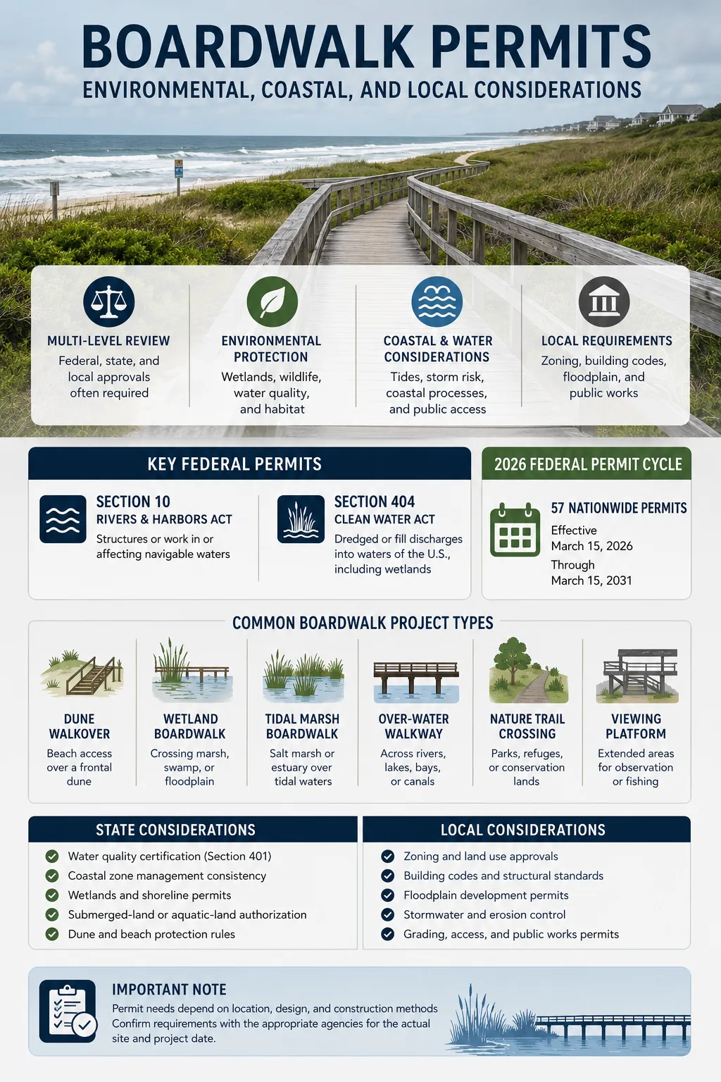
Section 10 structures or work; Section 404 dredged or fill discharges
Water quality, wetlands, coastal construction, dunes, shoreline use
Zoning, building, floodplain, grading, stormwater, public works
57 Nationwide Permits effective March 15, 2026 through March 15, 2031
Scope note: This page explains common U.S. permitting paths for boardwalk construction, reconstruction, repair, and expansion. It is not a parcel-specific jurisdictional or permit decision. Agency boundaries, regional permit conditions, state law, local codes, and protected-resource findings must be checked for the actual site and project date.
Why the Type of Boardwalk Changes the Permit Path
Regulators review the activity and its effects rather than the label printed on a concept plan. The first useful step is to classify the structure by setting, support system, public use, and construction method.
| Boardwalk Type | Typical Setting | Permit Questions That Usually Lead the Review |
|---|---|---|
| Urban oceanfront boardwalk | Developed beachfront or commercial waterfront | Coastal construction line, flood and wave exposure, public access, local building review, historic character |
| Dune walkover | Beach access across a frontal dune | Dune vegetation, siting over the dune crest, turtle or shorebird timing, lateral beach access, storm-breakaway design |
| Freshwater wetland boardwalk | Marsh, swamp, wet meadow, or floodplain | Wetland delineation, federal and state jurisdiction, piles, approach fill, temporary mats, restoration |
| Tidal marsh boardwalk | Salt marsh, estuary, tidal creek edge | Section 10, Section 404, mean high water, fish habitat, shading, pile installation, submerged-land rights |
| Over-water walkway | River, bay, lake, canal, or harbor | Navigation, structure location, pile spacing, waterward projection, public trust use, state aquatic-land authorization |
| Nature-trail crossing | Park, refuge, conservation land, or forest | Land-manager approval, wetlands, species, cultural resources, outdoor accessibility, construction access |
| Viewing or fishing platform | Attached to a trail or extending over water | Added width and shade, occupancy, rail openings, accessible user spaces, Section 10 or state shoreline review |
| Repair or replacement | Existing boardwalk alignment | Maintenance limits, changed footprint, new piles, route shifts, higher capacity, emergency procedures |
A narrow crossing can create more permit work than a much larger upland promenade when the narrow structure enters regulated wetlands, crosses tidal water, or requires temporary fill. Conversely, a large city boardwalk may avoid federal wetland jurisdiction yet still face demanding coastal engineering, floodplain, public-access, zoning, and building requirements.
The Regulatory Footprint Is Larger Than the Finished Deck
Permit drawings must account for the entire construction footprint. Reviewing only the square footage of finished decking can miss the activities that actually trigger authorization.
Permanent Elements That Belong in the Impact Calculation
- Decking, joists, beams, caps, piles, footings, anchors, and concrete collars
- Ramps, stairs, landings, passing spaces, benches, overlooks, and fishing platforms
- Railings, edge protection, lighting, utility conduits, signs, and emergency equipment
- Approach walks, trail connections, retaining elements, riprap, drainage outlets, and parking connections
- Permanent vegetation clearing, grading, excavation, fill, or altered drainage
Temporary Work That Can Trigger Its Own Authorization
- Construction mats, corduroy roads, temporary access fills, and equipment crossings
- Cofferdams, work pads, temporary platforms, scaffolding, barges, and dewatering areas
- Crane positions, pile-driving access, material staging, spoil storage, and worker routes
- Temporary vegetation removal, trenching, pumping, sediment controls, and bank disturbance
Field distinction: A pile-supported deck described as “no fill” may still involve regulated discharge through concrete, approach fill, excavated material, access mats, cofferdams, or temporary work areas. U.S. Army Corps guidance states that temporary discharges and temporary fills can require authorization just as permanent work can.
Map the Legal Boundaries Before Fixing the Alignment
“Near the water” is not a usable permit boundary. Boardwalk design depends on surveyed or professionally delineated lines that may be based on different laws, datums, field indicators, or agency methods.
| Boundary or Resource | Why It Matters to a Boardwalk |
|---|---|
| Wetland delineation | Locates aquatic-resource limits and supports federal, state, or local impact calculations |
| Ordinary High Water Mark | Often helps define lateral jurisdiction in non-tidal waters |
| Mean High Water Line | Used in tidal settings for navigation jurisdiction, shoreline regulation, and some property questions |
| High tide or tidal limits | May affect federal or state review beyond the surveyed mean high water line |
| Dune toe, crest, and vegetation line | Controls walkover siting, elevation, vegetation disturbance, and beach access design |
| Coastal construction line or setback | Marks where special state siting and structural rules apply |
| FEMA flood zone and floodway | Can trigger local floodplain approval, elevation data, hydraulic review, or no-rise documentation |
| State-owned submerged land | May require a lease, license, easement, consent, or other proprietary approval |
| Public access corridor | Can limit gates, private encroachment, deck placement, or interruption of lateral access |
| Protected habitat or cultural area | May change route, construction season, lighting, equipment access, or survey needs |
Mean High Water Line and Ordinary High Water Mark are not interchangeable terms. Tidal shorelines, non-tidal rivers, wetlands, and state property boundaries can rely on different lines. A survey must state the datum, method, date, and purpose of each line rather than displaying an unexplained “water line.”
How Federal Permits Enter a Boardwalk Project
The U.S. Army Corps of Engineers administers two federal authorities that frequently appear in boardwalk work. They address different activities, so a project can fall under one, both, or neither.
Section 10 Covers Structures and Work in Navigable Waters
Section 10 of the Rivers and Harbors Act applies to structures or work in, over, or under navigable waters of the United States, as well as work that affects their course, location, condition, or capacity. An over-water boardwalk, viewing platform, pier-like extension, pile-supported walkway, excavation, or material placement may therefore require a Department of the Army authorization even when the design does not discharge fill.
This is why the statement “the boardwalk uses piles, so no federal permit is needed” is unreliable. A pile-supported structure may avoid some forms of fill while still creating a Section 10 structure or work activity.
Section 404 Focuses on Dredged or Fill Material
Section 404 of the Clean Water Act generally requires authorization before dredged or fill material is discharged into waters of the United States, unless a statutory exemption applies. Boardwalk-related triggers can include approach fill, concrete foundations, riprap, wetland grading, access roads, temporary pads, cofferdams, and disposal of excavated material in a regulated aquatic area.
Piles require a fact-specific review. The installation method, pile type, associated excavation, concrete, displacement, and purpose of the structure can affect the analysis. The safer planning assumption is that the Corps reviews the full construction method, not only the finished pile count.
Section 401 Adds State or Tribal Water Quality Review
When a federal license or permit may result in a discharge into waters of the United States, Section 401 gives the relevant state or authorized Tribe a role in granting, denying, conditioning, or waiving water quality certification. For a boardwalk project, the review may address turbidity, erosion, concrete handling, treated materials, fuel controls, wetland hydrology, restoration, and monitoring.
Section 401 is not a replacement for Section 404, Section 10, or a state wetland permit. It is a connected water-quality decision within the federal licensing or permitting path.
Jurisdictional Determinations and the “No Federal Permit” Problem
A U.S. Army Corps Jurisdictional Determination can identify aquatic resources and state whether federal Section 404 or Section 10 jurisdiction is present. An approved determination is an official Corps position for the reviewed area, while a preliminary determination generally treats mapped aquatic resources as potentially jurisdictional for planning without making the same final finding.
A federal finding does not decide state or municipal coverage. A wetland outside federal Clean Water Act jurisdiction may remain regulated by a state wetland statute, a coastal program, a shoreline ordinance, a local buffer, or a floodplain code. “No Corps permit required” is not the same statement as “no permit required.”
Coastal Consistency and State Shoreline Programs
The Coastal Zone Management Act gives participating coastal states a role in reviewing certain federal actions, permits, licenses, and financial-assistance activities for consistency with the enforceable policies of an approved state coastal management program. The lead state agency and listed-activity rules differ by state.
A boardwalk can enter coastal consistency review through a Corps permit, federal funding, federal land, or another federal connection. The project may be tested against policies for dunes, public access, wetlands, scenic resources, erosion, fisheries, shoreline use, and water-dependent development. Some activities outside the mapped coastal zone can also be reviewed when the state program identifies the activity and geographic area and coastal effects are reasonably foreseeable.
State Permits That May Sit Beside the Federal Review
- Coastal development or coastal construction permit
- Freshwater or coastal wetland permit
- Waterfront development or shoreline alteration permit
- Beach, dune, or coastal setback authorization
- Flood-hazard-area or stream-encroachment approval
- State endangered-species or habitat review
- Sovereign, public-trust, or submerged-land lease, license, easement, or consent
- State water quality certification or waiver
Separate roles: A regulatory permit authorizes an activity under an environmental or land-use law. A proprietary approval grants the right to occupy or use land controlled by another owner or by the state. One does not automatically supply the other.
Species, Fish Habitat, Historic Properties, and Federal Review
A federal permit, federal grant, or federal land decision can bring other reviews into the permit schedule. These reviews are not decorative attachments to the application; they can alter the alignment, width, work season, lighting, pile method, and platform layout.
Endangered Species Act Consultation
Section 7 applies to actions that federal agencies authorize, fund, or carry out when discretionary federal involvement is present. Coastal and wetland boardwalk reviews may examine sea turtles, shorebirds, marsh birds, listed plants, fish, marine mammals, or designated critical habitat.
Possible project measures include seasonal work windows, pre-construction surveys, biological monitoring, reduced lighting, shielded fixtures, route shifts, limits on vegetation removal, vibration controls, or a different pile-installation method.
Essential Fish Habitat Consultation
Federal agencies must consult with NOAA Fisheries when their actions may adversely affect Essential Fish Habitat. A tidal boardwalk or over-water platform may be reviewed for shading, pile density, sediment disturbance, submerged vegetation, marsh-edge effects, and changes to water movement. A wider viewing deck can create a different habitat effect than a narrow crossing even when both use the same alignment.
Section 106 and Cultural Resources
Section 106 of the National Historic Preservation Act requires federal agencies to consider effects on historic properties when they carry out, assist, fund, permit, license, or approve a project. Review can apply to historic boardwalk fabric, adjacent historic districts, archaeological sites, submerged cultural resources, and places of Tribal interest.
Replacing an old boardwalk with modern materials can affect historic character even if the route stays in place. Ground disturbance for new piles, utilities, ramps, or lighting can also reach archaeological deposits beyond the visible structure.
NEPA Is a Federal Decision Process, Not a City Building Permit
The National Environmental Policy Act applies to federal agency decisions. A boardwalk can enter NEPA review through a federal permit, grant, land-management action, or direct federal construction. The level of review depends on the federal action and agency procedures; a boardwalk should not be assumed to require an environmental impact statement merely because NEPA is involved.
Why the Same Boardwalk Can Receive Different State Treatment
New Jersey: Several Coastal and Wetland Paths Can Overlap
New Jersey’s land-use program states that trail, boardwalk, and bike-path construction or reconstruction may require authorization according to the project location and effects on regulated special areas such as freshwater wetlands, coastal wetlands, shellfish areas, inundation-risk zones, and intertidal or subtidal shallows. The state also provides activity-specific permit routes for certain trails, boardwalks, and elevated timber dune walkovers.
A project may qualify for a limited exemption or streamlined state authorization under one rule while remaining subject to another coastal, wetland, flood-hazard, tidelands, or local requirement. The exact rule edition and application form should be checked at filing because New Jersey updates its online guidance and permit materials.
Florida: Dune Walkovers Are Shaped by the CCCL Program
Florida’s Coastal Construction Control Line program applies special siting and design criteria to work in the seaward beach zone. The program regulates structures and activities that can destabilize dunes, increase erosion, damage upland property, interfere with public access, or harm sea turtles and dune plants. Florida publishes separate beach and dune walkover guidance because the route, elevation, support system, vegetation disturbance, and waterward extent all affect the review.
The CCCL is a regulatory line, not a statement that all construction seaward of it is prohibited. A project can require a general permit, individual permit, field authorization, waiver, or another approval according to its location and scope. Work on state-owned land seaward of the mean high water line may also require separate consent from the state landowner.
Local Approval Continues After Environmental Review
Federal and state environmental permits do not replace municipal land-use or construction approval. A city or county may review the boardwalk as a structure, public facility, trail, assembly area, shoreline improvement, commercial use, or floodplain development.
| Local Review | Boardwalk Issues Commonly Examined |
|---|---|
| Zoning or site plan | Use, setbacks, height, operating area, public access, parking, commercial elements |
| Building permit | Structural loads, guards, handrails, materials, corrosion, stairs, ramps, inspection |
| Floodplain development | Flood zone, floodway, elevation, obstruction, debris, scour, hydraulic effect |
| Grading or land disturbance | Excavation, fill, vegetation clearing, erosion control, stockpiles, restoration |
| Stormwater | Runoff from approaches, parking, roofs or kiosks, outfalls, water-quality treatment |
| Public works or right-of-way | Connections to sidewalks, roads, utilities, drainage systems, maintenance access |
| Historic or design review | Materials, profile, lighting, railing pattern, views, district character |
| Electrical permit | Lighting, receptacles, utility routing, wet-location equipment, emergency systems |
| Special use or variance | Events, commercial uses, service vehicles, deviations from setbacks or height limits |
A nature boardwalk restricted to pedestrians may be reviewed differently from a promenade carrying maintenance carts, emergency vehicles, kiosks, ticketed events, or fishing use. Occupancy and operations should be defined before structural and permit drawings are finalized.
Ownership and Access Rights Must Be Solved Separately
A permit does not grant permission to build on land controlled by someone else. The alignment should be checked against private parcels, municipal land, state parks, federal property, conservation easements, drainage easements, utility corridors, Tribal land, public-access corridors, and state-owned aquatic land.
- Fee ownership: who owns each segment of land beneath and beside the route
- Easements: whether the recorded purpose allows a public boardwalk, construction access, utilities, or maintenance
- Submerged-land rights: whether piles or platforms occupy state-controlled beds of tidal or navigable water
- Public trust and beach access: whether the project narrows, redirects, gates, or privatizes an existing public route
- Construction rights: whether cranes, mats, barges, staging, or temporary crossings extend outside the permanent easement
Common title problem: A narrow permanent easement may cover the finished deck but not the wider temporary area needed for pile driving and material delivery. Construction rights should be mapped with the same care as permanent ownership.
Design Choices That Can Change the Permit Result
Permit work is easier when avoidance and impact reduction are built into the first alignment rather than added after agencies identify conflicts. Small changes in route, width, support type, or construction access can move a project into a different authorization path.
| Design Decision | Permit Effect to Examine |
|---|---|
| Alignment | Wetland crossing length, dune cuts, habitat fragmentation, property rights, archaeological disturbance |
| Deck width | Shading, pile count, public capacity, passing needs, construction staging, platform classification |
| Elevation | Tidal flow, vegetation light, wildlife passage, wave and debris exposure, ramp length, adjacent views |
| Pile spacing | Habitat obstruction, navigation, structural loads, equipment method, scour, number of bottom disturbances |
| Foundation type | Excavation, vibration, concrete, soil displacement, access needs, removability, contaminated sediment |
| Viewing platform | Extra shading, occupancy, rail design, accessible spaces, fishing use, waterward projection |
| Lighting | Turtle and bird effects, glare, neighboring properties, operating hours, utility trenching |
| Approach ramp | Additional fill, longer wetland footprint, handrails, landings, property limits, flood obstruction |
| Construction access | Temporary fill, mats, vegetation removal, bank entry, barge use, restoration obligations |
| Material system | Treatment chemicals, heat, slip behavior, storm debris, corrosion, maintenance frequency |
Lighting Can Become a Habitat and Use Issue
Lighting should be defined during environmental review rather than added after permit issuance. Fixture height, shielding, color, intensity, operating schedule, beach visibility, and trenching can affect species consultation and local approval. A boardwalk approved as a daytime nature route may need a permit modification before it becomes a lighted nighttime facility.
Accessibility Must Be Coordinated With the Environmental Footprint
Accessible design can affect width, ramp length, landings, rest areas, rail details, and the amount of wetland or dune crossed. Leaving it until the end can force a wider or longer structure after impact calculations have already been submitted.
- Accessible route from parking, sidewalk, trailhead, transit stop, or facility entrance
- Clear width, passing spaces, turning areas, resting intervals, and platform user spaces
- Running slope, cross slope, transitions, level changes, and ramp landings
- Firm and stable surfaces, deck-board gaps, drainage openings, and protruding objects
- Guard and rail design that provides safety without blocking seated views
- Connections to accessible parking, restrooms, seating, fishing positions, and overlooks
The U.S. Access Board’s outdoor developed area standards apply to covered federal facilities and distinguish trails, outdoor recreation access routes, viewing areas, and beach access routes. State and local government facilities and private facilities may be governed by ADA standards and other codes instead. The correct route category and owner type should be identified before dimensions are copied from a reference detail.
For federal outdoor recreation access routes built with a clear width below 60 inches, the Access Board standards require passing spaces at prescribed intervals; the guidance also advises designers to consider wider or more frequent passing areas where a boardwalk is elevated above adjacent ground. Board gaps and other openings must also be controlled so mobility-device wheels, cane tips, or crutches are not trapped.
Documents That Make a Boardwalk Permit File Reviewable
Not every project needs every study. The application package should match the site, regulatory boundaries, and likely effects. Drawings submitted to different agencies should use the same alignment, pile count, dimensions, datum, and construction method.
Base Plans and Engineering Drawings
- Boundary and topographic survey with datum and benchmark
- Existing-conditions plan with wetlands, water lines, dunes, vegetation, flood zones, utilities, and property limits
- Plan, profile, cross-sections, pile schedule, foundation details, and deck elevations
- Permanent and temporary impact plan with separate quantities
- Construction access, staging, erosion-control, dewatering, and restoration plans
- Material specifications, lighting schedule, rail details, and accessibility dimensions
Studies Added When the Site Requires Them
- Wetland delineation and Corps jurisdiction request
- Ordinary high water or mean high water survey
- Coastal, wave, debris, scour, geotechnical, hydrologic, or hydraulic analysis
- Species, shorebird, turtle, submerged vegetation, or fish-habitat survey
- Archaeological, architectural-history, or Tribal cultural-resource work
- Alternatives analysis, public-access study, restoration plan, and monitoring plan
Impact Quantities Should Be Separated, Not Blended
A permit impact table is more useful when it separates permanent wetland loss, temporary wetland disturbance, open-water work, shading area, pile count, fill volume, excavation volume, vegetation removal, dune disturbance, and restoration area. Combining all effects into one deck-area figure can conceal the activity each agency regulates.
General Permits, Individual Permits, and the 2026 NWP Cycle
There is no single Nationwide Permit named for every permanent boardwalk. The applicable authorization depends on the activity. Maintenance, recreational facilities, minor discharges, temporary construction access, emergency work, and other components may be evaluated under different national, regional, state-programmatic, or individual permit paths.
The U.S. Army Corps reissued 56 Nationwide Permits and added one new permit for a total of 57 permits effective March 15, 2026. They expire March 15, 2031. The 2026 list includes NWP 3 for maintenance, NWP 33 for temporary construction, access and dewatering, and NWP 42 for recreational facilities, but a boardwalk qualifies only when the regulated activity meets the selected permit’s terms, national conditions, regional conditions, water-quality conditions, coastal determinations, and any case-specific conditions.
Some Nationwide Permit activities require a Pre-Construction Notification and written verification before work; others can proceed without reporting only when every applicable term and condition is met. Species, historic-property, regional, or waiver provisions can require written review even where the permit text appears otherwise usable.
| Authorization Path | Typical Use | Boardwalk Planning Meaning |
|---|---|---|
| Exemption or no regulated activity | A narrow set of activities meeting exact legal limits | Must be confirmed across federal, state, local, and property programs |
| Permit by rule, registration, or certification | State-defined low-impact work | Usually depends on fixed dimensions, location limits, and required notices |
| Nationwide or regional general permit | Activities expected to have no more than minimal effects | Regional conditions and notification rules can change the apparent national path |
| Letter of permission | Certain minor Section 10 work with limited public-interest concerns | Availability depends on Corps procedures and project context |
| Individual permit | Work outside general-permit limits or requiring project-specific review | Usually needs fuller alternatives, public-interest, and environmental documentation |
| Variance or exception | Departure from a state or local dimensional or siting rule | Approval is discretionary and should not be assumed during early design |
Federal Rule Status on July 25, 2026
Nationwide Permits: The 2026 NWP cycle is in effect from March 15, 2026 through March 15, 2031. District and division regional conditions must be checked for the state and Corps district where the work occurs.
Waters of the United States: EPA and the Army announced a proposed updated definition in November 2025, and the comment period closed January 5, 2026. EPA’s WOTUS page, updated June 25, 2026, continued to identify it as a proposed rule. Applicants should use the agencies’ current implementation and litigation-status materials rather than treating the proposal as final.
Section 401: EPA proposed revisions in January 2026, with comments closing February 17, 2026. EPA’s current requirements page continued to identify 40 CFR Part 121 as the current regulation while listing the 2026 action as proposed. Permit documents should distinguish current requirements from proposal language.
A Practical Sequence for Coordinating the Permit Stack
- Confirm ownership and access rights. Identify every permanent and temporary parcel, easement, public corridor, and submerged-land interest.
- Map regulated boundaries. Delineate wetlands, survey water lines, locate dunes and coastal lines, and map flood zones and habitat constraints.
- Define the entire project. Include approaches, parking connections, utilities, lighting, overlooks, temporary access, staging, and restoration.
- Meet agencies before locking the design. Coordinate with the Corps district, state wetland or coastal office, local floodplain administrator, landowner, and resource agencies as needed.
- Prepare lower-impact alternatives. Compare alignments, widths, foundation methods, temporary access routes, and platform sizes.
- Match drawings and impact totals. Use one controlled design version across federal, state, and local submissions.
- Coordinate connected reviews. Track Section 401, coastal consistency, species, fish habitat, historic properties, land rights, and local approvals with the primary permit.
- Carry permit conditions into procurement. Put seasonal restrictions, access limits, monitoring, restoration, and reporting in the construction documents.
- Close the permits after construction. Submit as-built plans, photographs, certifications, restoration records, mitigation documentation, and monitoring reports when required.
How the Permit Stack Changes Across Five Boardwalk Projects
| Project Scenario | Likely Review Focus |
|---|---|
| New urban oceanfront boardwalk | State coastal permit, local floodplain and building review, wave and debris design, public access, historic district, federal review where water or wetlands are affected |
| Hotel dune walkover | Dune siting, vegetation, turtle and shorebird season, beach access rights, lighting, local building permit, state coastal line |
| Municipal freshwater wetland boardwalk | Wetland delineation, Section 404, state wetland permit, Section 401, temporary mats, accessible route, restoration and monitoring |
| Tidal marsh route with overlook | Section 10 and possible Section 404, coastal consistency, fish habitat, shading, pile method, submerged-land consent, platform occupancy |
| Storm-damaged boardwalk reconstruction | Emergency procedure, maintenance versus expanded replacement, FEMA or other federal funding review, changed flood standards, debris removal, historic character |
These are screening examples rather than permit determinations. A project can move between paths when the alignment, funding source, construction access, or ownership changes.
Repair, Replacement, and Expansion Are Not the Same Activity
An existing boardwalk does not create a permanent exemption for all future work. Routine maintenance is usually narrower than full replacement, and full replacement can become expansion when the route, width, elevation, support system, use, or capacity changes.
| Work Description | Permit Question |
|---|---|
| Replace isolated deck boards in kind | May fit maintenance treatment if footprint, use, and support system remain unchanged |
| Replace piles or footings | Creates in-water or wetland work that may need renewed federal, state, or local authorization |
| Shift the alignment | Creates a new impact area and may leave restoration obligations at the abandoned route |
| Widen the deck | Adds shading, piles, occupancy, access needs, and possibly a larger permit category |
| Raise the structure | May improve flood clearance but lengthen ramps and enlarge the environmental footprint |
| Add lighting or utilities | Can trigger habitat, trenching, electrical, and operating-hour review |
| Add a viewing platform | Changes width, use, rails, accessible spaces, shading, and waterward projection |
| Strengthen for service vehicles | Changes structural loading, width, operations, safety, and local code review |
Storm Damage Does Not Automatically Remove Permit Duties
Federal, state, and local agencies may offer emergency authorizations, field permits, expedited procedures, or disaster-specific coordination. Those paths normally limit the type, location, timing, and amount of work. Emergency safety actions, debris removal, temporary access, and permanent reconstruction should be separated in the scope so each can receive the proper approval.
Federal disaster funding can also introduce NEPA, Section 106, species, floodplain, or grant conditions that were absent from the original privately funded structure.
Permit File Errors That Commonly Delay Boardwalk Work
- Calculating only deck area and omitting piles, ramps, platforms, or temporary disturbance
- Calling the design “no fill” while showing concrete, riprap, approach fill, mats, or spoil placement
- Using an unverified wetland line or an unexplained water elevation as the jurisdiction boundary
- Submitting different alignments or pile counts to the Corps, state, and municipality
- Designing the accessible ramp after the wetland impact total has been fixed
- Leaving construction access, crane setup, staging, and dewatering out of the drawings
- Assuming a state exemption removes federal, local, or property approvals
- Assuming an old permit automatically covers a wider or relocated replacement
- Showing a public boardwalk across land without a recorded access or construction right
- Scheduling pile work during a protected-species restriction without agency coordination
- Ignoring the parking, sidewalk, utility, drainage, or shoreline work connected to the boardwalk
- Starting work before written verification where notification or consultation requires a written decision
Permit Conditions Continue Into Construction and Maintenance
The permit set should be part of the contractor’s documents. Conditions can control how and when the boardwalk is built, not merely where the final deck is placed.
- Seasonal work windows and daylight-only construction
- Pile-driving, noise, vibration, or biological-monitoring requirements
- Turbidity barriers, erosion controls, spill prevention, and fueling setbacks
- Approved equipment routes, mats, barges, and staging areas
- Limits on clearing, lighting, trenching, excavation, or material storage
- Removal of temporary fill and return to pre-construction elevations
- Wetland, dune, or shoreline replanting and survival monitoring
- Maintenance of navigation, public access, and emergency routes
- As-built drawings, completion certifications, photographs, and compliance reports
- Permit expiration, transfer, modification, and maintenance obligations
Construction control: A contractor change from hand-carried materials to heavy equipment, or from upland access to wetland mats, can alter the authorized method. Field changes should be checked against permit drawings and conditions before they are used.
Questions to Resolve Before the First Permit Meeting
- Does any part of the structure sit in, over, or under navigable water?
- Are wetlands, tidal flats, streams, lakes, marshes, beaches, or dunes inside the permanent or temporary footprint?
- Will the work use concrete, fill, riprap, excavation, mats, cofferdams, access pads, or spoil placement?
- Which water, wetland, dune, flood, property, and coastal lines have been surveyed or delineated?
- Is the project inside a state coastal zone, shoreline district, floodway, or coastal construction area?
- Does the route enter state-owned submerged land, a public-access corridor, an easement, or land controlled by another agency?
- Is federal funding, federal land, a Corps permit, or another federal approval involved?
- Could listed species, Essential Fish Habitat, historic properties, archaeological sites, or Tribal interests be affected?
- Is the work true maintenance, in-kind replacement, reconstruction, relocation, widening, or a new use?
- Are accessibility, public capacity, lighting, fishing use, and service vehicles already included in the design?
- Does the temporary construction plan match the impact table?
- Have the responsible Corps district, state agencies, landowner, and local floodplain and building officials reviewed the same concept?
Boardwalk Permit Questions With Direct Answers
Does a Pile-Supported Boardwalk Need a Section 404 Permit?
Sometimes. Section 404 depends on a discharge of dredged or fill material into waters of the United States. The pile method, concrete, excavation, approaches, temporary access, mats, cofferdams, and spoil handling must all be reviewed. Section 10 can apply separately in navigable water even when Section 404 does not.
Is a Private Boardwalk Exempt From Coastal or Wetland Permits?
No general private-property exemption applies simply because public access is restricted. Ownership can change land-use and accessibility issues, but federal, state, coastal, wetland, floodplain, and building rules may still apply.
Can a Boardwalk Be Rebuilt in the Same Footprint Without New Approval?
Not automatically. The original permit, maintenance provisions, pile work, temporary access, storm damage, current code, and any changes in width, height, material, capacity, or alignment must be checked. Some agencies offer maintenance or emergency paths, but eligibility is scope-specific.
Do Temporary Construction Mats Count as an Impact?
They can. Temporary access fills, work pads, mats, cofferdams, and dewatering structures may require authorization and are commonly shown as separate temporary impacts. Permit conditions may require complete removal, return to prior elevations, stabilization, and revegetation.
Does a Local Building Permit Replace a Corps or State Permit?
No. Building officials review construction under local or state building codes. Corps and state environmental agencies review separate water, wetland, coastal, habitat, and property authorities.
Can an After-the-Fact Permit Fix Unauthorized Boardwalk Work?
An agency may have an after-the-fact process, but approval is not assured. Unauthorized work can lead to stop-work orders, restoration, penalties, removal, or a permit review that requires design changes. It should not be treated as a planned alternative to pre-construction authorization.
Can Lighting Be Added After the Boardwalk Is Permitted?
Possibly, but the addition may require permit modification, local electrical approval, and renewed species or coastal review. Lighting can change habitat effects, operating hours, trenching, glare, and public use.
Official Sources and Verification
Regulatory status on this page was checked on July 25, 2026. Project applicants should verify the current rule, regional conditions, forms, and agency contacts before filing or beginning work.
- U.S. Army Corps of Engineers — Nationwide Permit Information
- Federal Register — 2026 Nationwide Permit Final Action
- U.S. Army Corps of Engineers — Section 10 of the Rivers and Harbors Act
- U.S. Environmental Protection Agency — Section 404 Permit Program
- U.S. Army Corps of Engineers — Jurisdictional Determinations
- U.S. Environmental Protection Agency — Section 401 Regulatory Requirements
- U.S. Environmental Protection Agency — Waters of the United States Status
- NOAA Office for Coastal Management — Federal Consistency
- U.S. Fish and Wildlife Service — Endangered Species Act Section 7 Consultation
- NOAA Fisheries — Essential Fish Habitat Consultations
- Advisory Council on Historic Preservation — Section 106
- Council on Environmental Quality — NEPA Resources
- U.S. Access Board — Outdoor Developed Areas
- New Jersey Department of Environmental Protection — Trails, Boardwalks and Bike Paths
- Florida Department of Environmental Protection — Coastal Construction Control Line Program